Dauphin Island · Local Government
Dauphin Island beach restoration: public funding and property rights
At a glance
Dauphin Island’s coastal projects combine public funding with property-access and environmental requirements. The Town reports West End construction funding secured, while private easements and planned design and bidding remain separate milestones. Causeway marsh restoration and bridge rehabilitation are different projects. Approved allocations and estimated project costs should not be presented as a verified total of money already spent.
Editorially updated . Evidence dates and record limits are stated separately.
Originally published · WorthFighting.org Editorial Team
This investigation examines public funding and property rights. For individual project milestones, use the West End restoration status tracker and the separate Causeway project guide. Property owners can also review the West End easement guide.
Dauphin Island restoration status: what changed and what comes next
| Project | Documented or reported status | Next step or record needed |
|---|---|---|
| West End beach and dunes | Town reports full funding secured, required permits issued and the POA easement recorded. | Private easements remain on the May–December 2026 schedule; design and bidding are planned for fall 2026, construction for winter 2027. A planned date is not a start notice. |
| Causeway shoreline | County reports Phase 1 complete September 2024 and Phase 2 sediment placement complete February 2026. | Phase 3 bid opening is posted for October 21, 2026 at 10 a.m.; an award and notice to proceed remain separate records. |
| East End EPA wetlands | Phase I concerns land acquisition and preliminary work. | A Town scope-change request does not establish EPA approval or completed wetlands. |
Sources rechecked October 5, 2026: Town West End project, Mobile County causeway stages, Phase 3 bid posting, Town EPA records. Earlier cost estimates below are not an audited spending total.
Dauphin Island is losing ground.
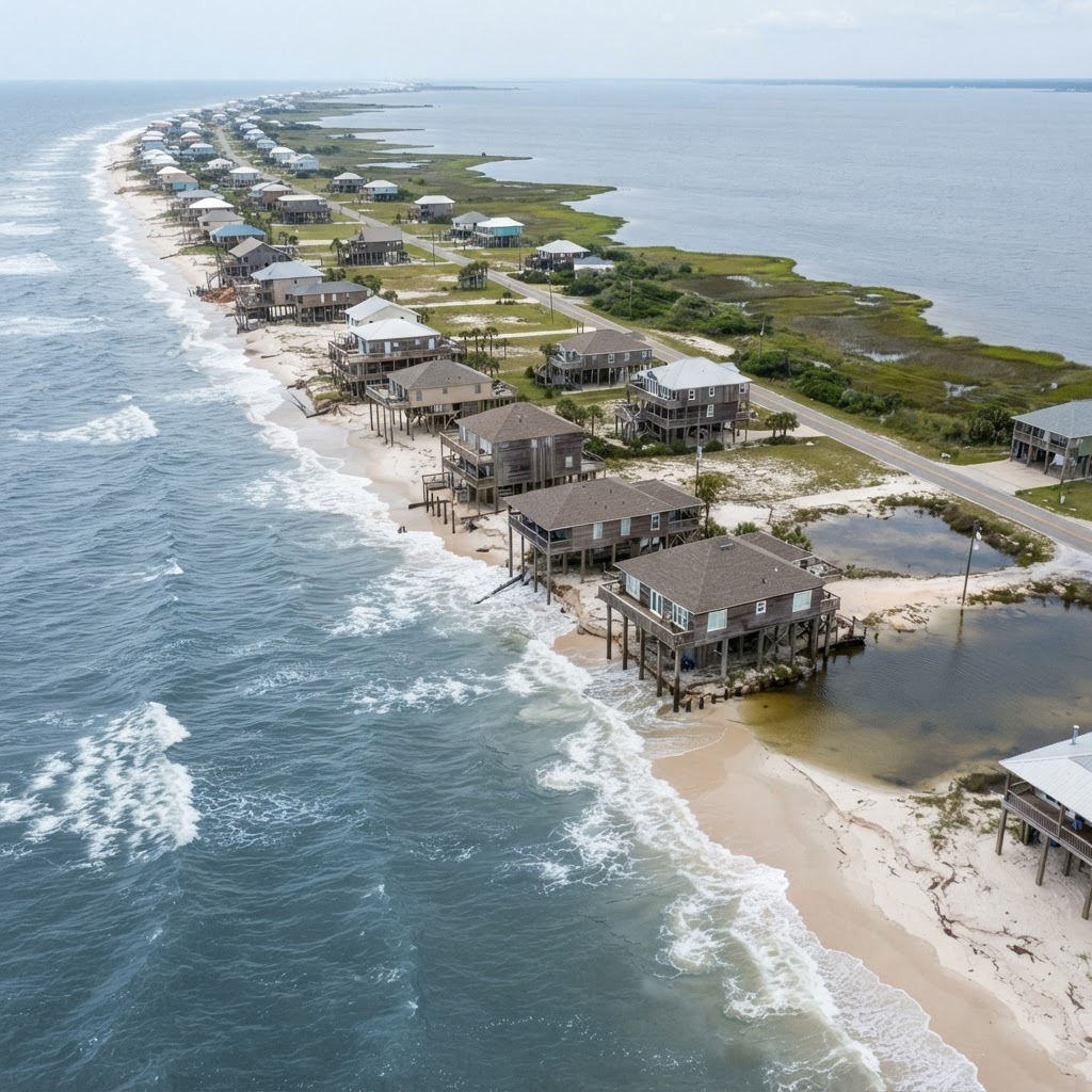
USGS satellite imagery tracking the island from 2004 through 2008 shows a barrier island shrinking before the camera. Hurricane Katrina cut a 1.5-mile-wide gap — the so-called "Katrina Cut" — straight through the west end in August 2005, destroying more than 300 homes and, for many of those homes, permanently washing away the land beneath them.
Twenty years later, the island is still eroding. And the fight to save it has become one of the most interesting conservative policy questions on the Gulf Coast: How much public money should government spend protecting a vulnerable barrier island — and what happens when protecting it requires easements, boundary changes, and restrictions affecting private property?
The Island Is Literally Disappearing
The U.S. Geological Survey has documented long-term erosion of Dauphin Island's Gulf shoreline across decades. The USACE Final Alabama Barrier Island Restoration Assessment Report, published in 2020, identified the west end as a priority for restoration based on 100-year erosion trends.
The physical evidence is visible to anyone who visits. "There are probably 50 lots in this stretch of the island" that have effectively disappeared beneath the Gulf, one resident told CBS News in 2025. Jillian Fairbanks, who visits frequently, described watching the beach retreat in real time: "Just about a year later, I can already tell that the sand has eroded, I'd say 30 meters or so at least."
The town's own project documents are blunt: "This sand will not come back naturally." Without intervention, erosion will persist, roads will continue to flood with blowing sand, and water and sewer infrastructure will remain at risk.
Hurricanes Ivan (2004), Katrina (2005), and Isaac (2012) each carved away portions of the island. Katrina Cut was eventually closed with a rock berm built after the BP oil spill, but the underlying erosion never stopped.
The West End Beach and Dune Restoration Project
The Town of Dauphin Island's answer is the West End Beach and Dune Restoration Project — the first-ever restoration project for the island's west end.
The project will place approximately 2.5 million cubic yards of sand dredged from a shoal roughly 10 miles offshore, widening the beach from roughly 170 feet to 590 feet across 3.5 miles of shoreline. It will construct linear dunes, restore approximately 160 to 200 acres of beach and dune habitat, and create 40 acres of sandy water bottom.
The total estimated cost is $50 to $60 million. In June 2026, Governor Kay Ivey announced that the Gulf Coast Ecosystem Restoration Council (RESTORE Council) had approved $38 million for the project — money derived from the BP Deepwater Horizon oil spill settlement.
The project is designed to protect more than private homes. According to the town, it will defend roads, water and sewer infrastructure, reduce the costly annual removal of sand from Bienville Boulevard, and provide protection for the estuarine habitats of the Mississippi Sound, including seagrasses, oyster reefs, marshes, and 30,000 acres of conservation lands.
"When constructed, the West End restoration project will prove to be a significant and transformative investment in coastal Alabama," Mayor Jeff Collier said when the funding was announced.
Scott Douglass, the coastal engineering consultant who designed the project, was more direct about the stakes. "We need to get a sand dune here. And we need a beach south of the sand dune. So, when the hurricane hits — and it will — it's basically a shock absorber," he told FOX10 News. "Without this project all of these houses would be destroyed in the next hurricane — just like they were in Hurricane Ivan and Katrina 20 years ago."
The timeline: final design in Fall 2026, bidding in Fall 2026, construction to commence in Winter 2027. The required USACE, ADEM, and Alabama Beach Act permits have been issued.
The Private-Property Easement Question
Here is where the story gets interesting for conservatives.
The project cannot place sand on private property without the owner's permission. The Town is seeking construction and monitoring easements from affected property owners, with easement acquisition running from May 2026 through December 2026.
The easement area is limited — generally extending from the southern boundary of the property to approximately the +5-foot elevation contour, or to existing structures such as porches or pilings. The easement authorizes the Town to construct and maintain shoreline protection improvements and allows limited periodic access for monitoring, surveying, and minor maintenance.
Crucially, the easements are voluntary. No eminent domain has been discussed. If a property owner chooses not to sign, sand will not be placed on that property. The project will proceed seaward of the property line, and the lot will not receive the same beach improvements. The owner may be left with a low area that retains water — to be addressed at the owner's discretion and expense.
This creates a genuine property-rights tension. On one side: a homeowner should not be forced to grant government access to private property, even for a publicly funded project. On the other: if owners refuse the access necessary to perform the work, should taxpayers spend millions protecting a community where the protection cannot be fully implemented?
The project has overwhelming support. Alabama Commissioner of Conservation Chris Blankenship noted that a December referendum by the property owners' association found 967 in favor and 29 opposed. But the 29 matter — and so does the principle.
Who Owns the New Beach?
The most interesting property-rights question is not about easements. It is about the boundary line itself.
Under Alabama law, coastal property owners own land to the mean high tide line (MHTL). Land below that line — the wet beach — is owned by the state in trust for the public.
To qualify as an "engineered beach" under the Alabama Beach Act, the West End project established a designated MHTL. That designation is permanent. According to the town's own project documents, the designated MHTL "establishes the separation between private and public property in perpetuity — even if more erosion occurs in the future."
This is what troubles some property owners. Sam Mason, a west end owner, told FOX10 News: "If you adopt this Mean High Tide Line even without funding — it's going to permanently destroy our lots. My lot is going to be fully restored and I'll come down and look at it — but I won't own it anymore. It's sad."
The counterargument: the project adds 200 acres of public beach habitat, and an engineered beach designation allows the town to seek FEMA funding for future storm recovery. The boundary is fixed, but the public gains access and the community gains resilience.
The conservative question is whether government should be able to fix a property boundary in perpetuity as a condition of a publicly funded project — and whether the public, having paid for the sand, should gain public beach in return.
The $33.66 Million Bridge
The erosion fight is only part of the public investment. The Dauphin Island Bridge — the island's only connection to mainland Alabama — is undergoing a $33.66 million rehabilitation by the Alabama Department of Transportation.
The project is funded roughly 80% federal and 20% state. Contractor Southern Road & Bridge, LLC began work on September 30, 2025, repairing saltwater-damaged concrete beneath the bridge. The project is expected to take five years.
The bridge serves roughly 1,800 permanent residents but a far larger tourism economy. The question: how much should taxpayers invest in maintaining infrastructure serving a small permanent population but a much larger visitor base?
The Only Evacuation Route
The Dauphin Island Causeway is the island's sole evacuation route. Protecting it is a different category of government spending than subsidizing an individual beachfront house.
The $35 million Dauphin Island Causeway Shoreline Restoration Project is a partnership between the U.S. Army Corps of Engineers and Mobile County. Phase 1, reported complete in September 2024 by Mobile County, placed more than 150,000 tons of rock to create 3.5 miles of segmented breakwaters. Mobile County reports Phase 2 completed in February 2026, with 900,000 cubic yards of dredged sediment placed between the breakwaters and causeway. Phase 3 is planned for fall 2026–spring 2027; the October 21, 2026 bid deadline does not establish an actual construction start.
The causeway project is funded through USACE and Mobile County, using dredged material that would otherwise be disposed of offshore. It protects the only road on and off the island — the kind of core infrastructure responsibility that most conservatives would agree government should provide.
$13 Million More for Little Dauphin Island
In July 2026, the Mobile County Commission accepted $13 million in National Fish and Wildlife Foundation grants for the Little Dauphin Island Restoration Project. The project will restore approximately 130 acres of degraded beach and dune habitat using roughly 1.1 million cubic yards of dredged material from the Mobile Harbor Ship Channel.
The funding breaks down: $10 million from NFWF's Gulf Environmental Benefit Fund (a Deepwater Horizon settlement fund) and $3 million from NFWF's National Coastal Resilience Fund (established by Congress in 2018). No local match is required.
The project protects approximately 850 acres of the Bon Secour National Wildlife Refuge and buffers Dauphin Island Bay from wave energy. That earlier construction forecast does not establish an actual start; a current project notice is needed.
The Airbnb Connection
The island's erosion fight becomes even more complicated when the homes protected by publicly funded infrastructure and shoreline projects are also being operated as short-term vacation rentals. Many of the west end properties that stand to benefit from $50 to $60 million in public beach restoration are not primary residences — they are investment properties rented through Airbnb and Vrbo.
That raises a question worth asking: should taxpayer-funded beach protection subsidize private vacation-rental income? WorthFighting.org has investigated that question separately in our investigation into Dauphin Island's Airbnb and short-term-rental controversy.
Conservative Questions That Deserve Answers
This is not a story with a single right answer. There are legitimate conservative principles on both sides.
Limited government and taxpayer protection asks: How much government spending is too much? Should taxpayers repeatedly rebuild vulnerable coastal communities? Are federal restoration grants responsible infrastructure investment — or another example of dependence on Washington? Should future development face stricter rules if taxpayers ultimately bear the disaster and infrastructure costs?
Property rights and essential infrastructure asks: Should government protect private beachfront property when owners have paid taxes and followed the rules? Should property owners surrender easements when a project benefits the entire island? Is protecting the island's only evacuation route a core government responsibility? Should publicly financed beach restoration result in greater public beach access?
The tension between these principles is the story. The RESTORE Council money is BP settlement money — not a direct congressional appropriation — but it is still public money, allocated by a federal council, for a project that will fix property boundaries in perpetuity. The bridge is 80% federal funds. The causeway is USACE. The Little Dauphin Island grants require no local match.
Dauphin Island is worth protecting. The harder question is who should pay to protect it — and how much control government should gain over private property in return.
The island's future will be decided in town council meetings, at the RESTORE Council, in ALDOT project updates, and in the easement decisions of individual property owners between now and December 2026. That is self-government at work — on an island that is, quite literally, washing away.
Frequently Asked Questions
How much will the Dauphin Island West End restoration cost?
The total estimated cost is $50 to $60 million. In June 2026, the RESTORE Council approved $38 million for the project, drawn from the BP Deepwater Horizon oil spill settlement. The Town now reports full construction funding secured; that is not a record of funds spent.
What is the mean high tide line on Dauphin Island?
Under Alabama law, coastal property owners own land to the mean high tide line (MHTL). Land below that line is owned by the state in trust for the public. The West End project established a designated MHTL under the Alabama Beach Act, which fixes the public-private boundary in perpetuity — even if future erosion occurs.
Are the West End easements mandatory?
No. The construction and monitoring easements are voluntary. If a property owner chooses not to sign, sand will not be placed on that property. The project will proceed seaward of the property line, and the owner may be left with a low area that retains water to address at their own expense. No eminent domain has been discussed.
How much is the Dauphin Island Bridge project?
The Dauphin Island Bridge rehabilitation is a $33.66 million ALDOT project, funded approximately 80% federal and 20% state. Construction began September 30, 2025, and is expected to take five years. The work repairs saltwater-damaged concrete beneath the bridge.
What is the Dauphin Island Causeway restoration?
The $35 million Dauphin Island Causeway Shoreline Restoration Project protects the island's only evacuation route. Phase 1 placed more than 150,000 tons of rock for segmented breakwaters. Mobile County reports Phase 2 sediment placement complete in February 2026. Phase 3 is planned for fall 2026–spring 2027; the October 21, 2026 bid deadline does not establish an actual construction start.
How much public money has been spent on Dauphin Island?
Recent and ongoing projects include approximately $50 to $60 million for the West End beach restoration, $33.66 million for the bridge rehabilitation, $35 million for the causeway restoration, and $13 million for Little Dauphin Island restoration — a sum of announced allocations and estimates, not an audited total of spending, funded through a mix of BP settlement money, federal grants, USACE appropriations, and federal-state highway funds.
The Bigger Picture: What Are Residents Fighting For?
The fight to save Dauphin Island's shoreline is part of a larger question about the island's future. Read our investigation into what residents are fighting to protect — from zoning and development to neighborhood character and property rights.
Related Dauphin Island guides
- Dauphin Island rules, restoration and visitor guides
- Dauphin Island East End EPA project: land acquisition and grant status
Updated October 5, 2026. Source dates and unresolved questions are identified above.
Sources and public records
- Town of Dauphin Island — West End Nourishment Project
- FOX10 News — Money coming for Dauphin Island West End Renourishment and Resilience (June 2026)
- FOX10 News — Dauphin Island looks to construct first-ever restoration project on West End Beach (March 2025)
- CBS News — 20 years after Hurricane Katrina, a barrier island in Alabama is still struggling (Aug 2025)
- ALDOT News — Bridge rehabilitation project on Dauphin Island Bridge to begin (Sept 2025)
- WKRG — Dauphin Island Bridge set for $33.66M rehabilitation
- NBC 15 — $33 million rehab for Dauphin Island Bridge to begin in April
- Mobile County — Little Dauphin Island Restoration Project (July 2026)
- NFWF — More Than $13 Million in New Awards for Restoration Projects in Alabama
- USACE — Dauphin Island Causeway Shoreline Restoration supplied by Mobile Harbor Dredging
- Mobile County — 2025 Restoration Project Activity
- USGS — Alabama Barrier Island Restoration Assessment at Dauphin Island
- NPS — Mississippi Coastal Improvements Program (MsCIP)
- Accessing the Alabama Coast — Common Law and Statutes (Beach Ownership)
- Thompson Engineering — Katrina Cut Berm
- GMC Network — Dauphin Island East End Beach & Dune Restoration